


Mad Mutt Marine GPS Navigator

Deskripsi Mad Mutt Marine GPS Navigator
I started writing this application as something that would be useful to me. Since that it has grown and I am rather pleased with it. It is an aid to marine navigation and must be used in conjunction with charts that are printed on that white stuff that is called (So I’m told) paper.
Features
•Designed by and for a sailor. You may find that some of the layouts look “big and blobby” at first sight, but they work at sea. Fiddly and fussy layouts do not.
•No network required. This app uses your phone’s GPS, it will work where there is no mobile network coverage (though you will need network coverage to share your logs and waypoints by email).
•Store unlimited waypoints (restricted in free version).
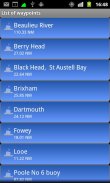
•View waypoints alphabetically of by distance from your current position.
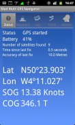
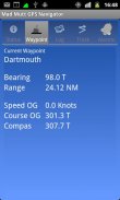
•Display range and bearing to a waypoint.
•Make logs of where you have been, which you can annotate with comments and other relevant data.
•View logs as display on the phone.
•Share logs with Google Earth on your phone or desktop computer, either by email or by copying KML files.
•Share waypoints with Google Earth on your phone or desktop computer, either by email or by copying KML files.
•Share logs with Google Earth on your phone or desktop computer, either by email or by copying KML files. Although I don’t encourage the use of Google Earth for marine navigation, seeing your waypoints on Google Earth is a useful visual check that you have transcribed them correctly.
•Anchor watch alarm service. Alerts you if you have moved more than a pre-defined distance. The anchor watch also alerts you if the battery level is low.
•Near waypoint alarm service
•Once started, the log, anchor and waypoint alarm services will continue to run, even if you quit the main navigator application. They will continue to run while you make phone calls or use your phone for email, Internet browsing or pretty much anything else.
What this application is not
It is not a chart plotter. This application is intended for marine navigation. Although it could be used by ramblers, that isn’t the main intention. It does not display digitised charts, nor does it show you a Google Map view with your position displayed on it. I believe it is highly irresponsible to encourage the use of Google maps to navigate boats. Even in rivers and estuaries, Google maps contain no semantics for the sea whatsoever; no lights and marks, depths, rocks etc. The application does allow you to send logs you have made to Google Maps, though, but only after you have completed the trip.
Free Version
For a limited time, a free version is available. In the Autumn of 2012 a full feature version should be available.
The free version has the following limitations:
•The number of waypoints you can have is restricted to 20.
•Routes are not availableSaya mulai menulis aplikasi ini sebagai sesuatu yang akan berguna bagi saya. Sejak itu telah berkembang dan saya agak senang dengan itu. Ini adalah bantuan untuk navigasi laut dan harus digunakan dalam hubungannya dengan grafik yang dicetak pada itu benda putih yang disebut (Jadi aku diberitahu) kertas.
Fitur
• Dirancang oleh dan untuk pelaut. Anda mungkin menemukan bahwa beberapa layout terlihat "besar dan Blobby" pada pandangan pertama, tetapi mereka bekerja di laut. Layout fiddly dan rewel tidak.
• Tidak ada jaringan yang diperlukan. Aplikasi ini menggunakan GPS telepon Anda, ia akan bekerja di mana tidak ada jangkauan jaringan selular (meskipun Anda akan perlu jangkauan jaringan untuk berbagi log Anda dan waypoints melalui email).
• Simpan waypoints terbatas (terbatas dalam versi gratis).
• View waypoints abjad dari menurut jarak dari posisi Anda saat ini.
• rentang Tampilan dan bantalan untuk waypoint.
• Buat log dari mana Anda telah, yang dapat Anda membubuhi keterangan dengan komentar dan data lain yang relevan.
• Lihat log sebagai tampilan di telepon.
• Share log dengan Google Earth di ponsel atau komputer desktop, baik melalui email atau dengan menyalin file KML.
• Share waypoints dengan Google Earth di ponsel atau komputer desktop, baik melalui email atau dengan menyalin file KML.
• Share log dengan Google Earth di ponsel atau komputer desktop, baik melalui email atau dengan menyalin file KML. Meskipun saya tidak mendorong penggunaan Google Earth untuk navigasi laut, melihat titik arah pada Google Earth adalah pemeriksaan visual yang berguna bahwa Anda telah ditranskripsi dengan benar.
• Layanan alarm Jangkar menonton. Alarm Anda jika Anda telah pindah lebih dari jarak yang telah ditentukan. Jangkar menonton juga memberitahu Anda jika tingkat baterai rendah.
• Dekat waypoint layanan alarm
• Begitu dimulai, log, jangkar dan jasa waypoint alarm akan terus berjalan, bahkan jika Anda keluar dari aplikasi navigator utama. Mereka akan terus berjalan sementara Anda membuat panggilan telepon atau menggunakan telepon untuk email, browsing internet atau cukup banyak hal lain.
Apa aplikasi ini tidak
Ini bukan bagan plotter. Aplikasi ini ditujukan untuk navigasi laut. Meskipun bisa digunakan oleh ramblers, itu bukan tujuan utama. Ini tidak menampilkan grafik digital, juga tidak menampilkan tampilan Google Map dengan posisi Anda ditampilkan di atasnya. Saya percaya itu sangat tidak bertanggung jawab untuk mendorong penggunaan peta Google untuk menavigasi perahu. Bahkan di sungai dan muara, peta Google tidak mengandung semantik untuk laut apapun; tidak ada lampu dan tanda, kedalaman, batu dll Aplikasi ini memungkinkan Anda untuk mengirim log yang telah Anda buat untuk Google Maps, meskipun, tetapi hanya setelah Anda menyelesaikan perjalanan.
Versi gratis
Untuk waktu yang terbatas, versi gratis tersedia. Pada musim gugur tahun 2012 versi fitur lengkap harus tersedia.
Versi gratis memiliki keterbatasan berikut:
• Jumlah titik arah Anda dapat memiliki dibatasi sampai 20.
• Rute tidak tersedia
Mad Mutt Marine GPS Navigator - Versi 1.07
(04-08-2014)
Mad Mutt Marine GPS Navigator - Informasi APK
Versi APK: 1.07Paket: uk.ac.plymouth.madmutt.gpsnavigatorVersi Terakhir dari Mad Mutt Marine GPS Navigator
Versi lain


Aplikasi pada kategori yang sama

Anda juga mungkin suka...
Aplikasi pada kategori yang sama


